5G drones come to the rescue
Drones are becoming common sights in search-and-rescue situations. In the future, drones connected to 5G could provide new types of information to help first responders save lives.
Full Transparency
Our editorial transparency tool uses blockchain technology to permanently log all changes made to official releases after publication. However, this post is not an official release and therefore not tracked. Visit our learn more for more information.
It’s the fall of 2021, in a mountainous area of the southeastern U.S. There’s an active Amber Alert—a young child has gone missing. It’s nearing dark, temperatures are dropping and they’re going to continue to drop in the coming days. The search and rescue experts, knowing that time is short, call in the drones.
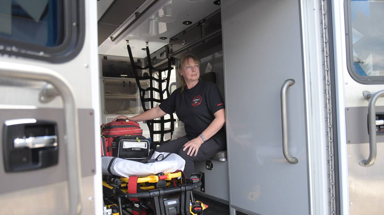
“I used a drone that had a thermal camera, so it was able to pick up differences in temperature that would help us see warmer things in the forest, even after dark,” says Chris Sanders, a member of the Verizon Frontline Crisis Response Team. And he wasn’t alone: A large team of drone pilots helped in the effort in order to cover the wide area where agencies thought the child could have gone—and they were able to cover a much larger area in a much shorter time than it would have taken if the search had only been on foot.
Thanks to that effort and those drones, the child was found early the next morning, safe, sound and only slightly cold. That outcome points to the benefits that drones—and in the future, 5G-connected drones—can bring to search and rescue efforts.
Drones help make sense of events, fast
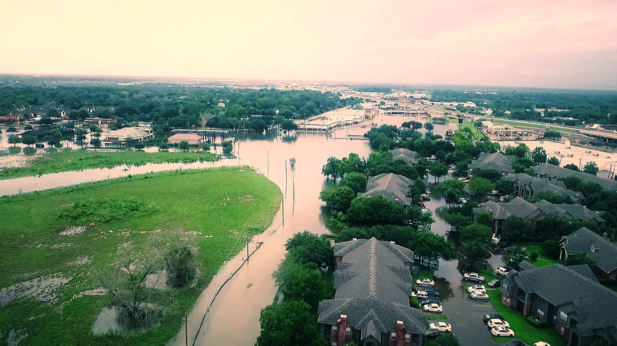
When disasters occur, it’s crucial for first responders to quickly understand conditions and have the information they need to make informed decisions. Lives, property and the safety of the search and rescue teams hang in the balance. But the chaotic nature of events creates enormous challenges for those responding to floods, fires, earthquakes, tornados and other emergencies. It’s often extraordinarily difficult for rescue teams and other first responders to know what’s actually taking place on the ground. In some cases, it’s also difficult to get vehicles into areas to determine where resources are required. Roads may be blocked, impassable or unrecognizable.
These situations are why drones are rapidly moving into the mainstream of search and rescue. And for good reason: Drones can quickly go where humans cannot easily go and view what they can’t see. As a result, not only do drones enhance tactical operations, they also reduce safety risks for responders and can significantly trim costs.
The technology has already been used to assess fires and floods in California and spot people trapped in ice in Colorado. And Verizon Frontline’s Tactical Humanitarian Operations Response (THOR) vehicle features a tethered drone (meaning it’s connected to THOR via a cable for power and communications) that is essentially a flying cell node. It can provide 5G service to first responders and the surrounding area—functions that it put to use in the aftermath of Hurricane Ian. “Drones have become valuable tools for emergency and rescue operations,” Sanders says.
5G drones could offer the next step in such operations. “With 5G drones, it should be possible to respond faster and better,” says Dr. Shay Har-Noy, CEO of Edgybees, a leading manufacturer of software used by drones for emergency services and rescues and a Verizon Ventures portfolio company. “[First responders] can do things that simply weren’t possible in the past.”
5G drones give a deeper view
The high speed and low latency that 5G can provide could introduce new and powerful capabilities for first responders and search-and-rescue teams. For drones used in emergency situations, any advanced sensing and operational capabilities—including autonomous navigation and two-way communication—must take place in near-real-time to be useful. 5G can help that data to travel quickly and with low lag so that emergency responders can quickly receive accurate and actionable information.
This performance could also help with one of the bigger challenges that emergency crews face: Orienting themselves after a fire, flood, tornado or earthquake has altered the landscape or destroyed landmarks. “You can’t use a satellite image to find and follow a road that’s submerged under three feet of water or see what’s happening in a forest that’s on fire,” Sanders says.
Augmented reality (AR) can help to solve this problem by overlaying satellite-provided mapping data, such as roads, on a live video feed of a flooded area. But a common challenge is that data from various sources doesn’t align, which can make it unreliable, says Har-Noy. When images and data are out of sync, it can hinder rescue efforts.
Har-Noy’s team at Edgybees is working on a solution that combines AI algorithms, satellite-provided data and 5G to overcome those issues and deliver locational accuracy within a few meters—even at night or with obscured visibility.
In this scenario, a 5G-capable drone would transmit live video feeds to servers that quickly work to realign geographic features and combine the live data with location information on streets and other landmarks. This information is sent back to crews on the scene so quickly that they can use AR to view the “live” video with an overlay of helpful location information, even when those features aren’t actually visible. “This level of information makes it possible to coordinate emergency response and rescue far more effectively,” Har-Noy says.
The 5G drone future for search-and-rescue
Faster and safer: Those are the two primary attributes that could make 5G drones increasingly attractive in search-and-rescue situations. In life-or-death scenarios, delays, guesses and approximations simply aren’t good enough. And because 5G services might not always be available in locations where search-and-rescue teams and first responders need to operate, Verizon Frontline recently introduced THOR’s Hammer, a 30-foot trailer that is able to provide a 5G private stand-alone network to support remote operations, which could someday support the work of 5G drones.
“Someone may be trapped in a car due to a flood, and you need to figure out where they are using video and mapping,” Har-Noy says. “With 5G drones enabling near-real-time data transfer, rescuers could see what’s there, even if they can’t see the road. They could also quickly determine what cars don’t have people in them and react accordingly.” This means rescuers would only deploy when and where needed—potentially making their work safer.
“When an organization has a clear idea of what’s actually taking place in the field, it’s possible to deploy the specific resources that are needed,” Sanders says. “Rescuers could then focus on doing their jobs safely—and save lives and property.”
Verizon is the most reliable 5G network in America1. See what 5G can do for you.
1 Most reliable 5G network based on more first place rankings in RootMetrics® 5G data reliability assessments of 125 metro markets conducted in 2H 2022. Tested with best commercially available smartphones on three national mobile networks across all available network types. Your experiences may vary. RootMetrics rankings are not an endorsement of Verizon.